|
|
Post by Joey on Feb 4, 2017 22:14:50 GMT 10
I have modified these to be suitable for the Southern Hemisphere.. DETERMINING DIRECTIONS WITHOUT A COMPASS There are two types of compasses, (a) liquid filled and (b) non-liquid filled. Liquid filled means the compass is filled with some special liquid so the magnetic needle floats freely inside of it. Non-liquid filled means there's no liquid inside of it (duh?) but instead the magnetic needle is able to rotate freely while being balanced on one or two pins inside the compass. So which is better? They both have their pros and cons, the only difference is that the North seeking magnetic needles inside liquid filled compasses rotate & move slower than non-liquid filled compasses. But regardless of which type of general direction compass you have or get with your survival kit, they're a lot more easier to use in determining directions than these techniques below "without a compass." SUN & STICK METHOD (Sunlight required) Steps 1, 2, & 3 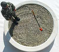 Steps 4 & 5 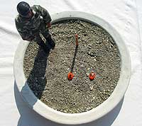 Steps 6 & 7 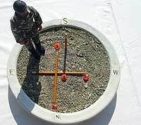 Step 1: Try to find some flat level area with very little or no vegetation at all. Step 2: Place a straight stick upright into the ground and find the stick's shadow. Step 3: Now place your 1st rock at the tip of the stick's shadow, this is your "West" mark. Step 4: Wait approximately 15, 20 or 30 minutes for the stick's shadow to move a few inches. Step 5: Now place another rock at the tip of this other stick's shadow, this is your "East" mark. Step 6: Now draw a straight line or place a straight stick from your "East" rock to your "West" rock. Step 7: And now draw another straight line or place another straight stick across your "East-to-West" line/stick and this is now your "North-South" line/stick. Note: The instructions listed above is for the Northern hemisphere, for the Southern hemisphere the only difference is that North and South are reversed, East and West remain the same. CLOCK or WATCH METHOD(Sunlight required) 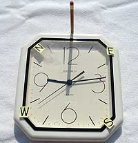 Southern Hemisphere Step 1: Point 12 O'clock at the sun Step 2: North is located halfway between 12 O'clock and the "hour hand." South is in the opposite direction. TREE METHOD(No sunlight required) South Side 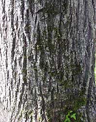 North Side 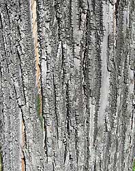 Wider grain on North side Moss grows on the South side In the Southern hemisphere trees with thick, rough, linear bark, the up & down grain lines are usually wider on the North side and tighter on South side. In the Southern hemisphere moss found near the base of trees usually grows on the Southern side where the sun's rays don't reach. www.survivaloutdoorskills.com/directions.htm |
|
paranoia
Senior Member

Posts: 1,098 
Likes: 1,252
Email: para@ausprep.org
|
Post by paranoia on Feb 4, 2017 22:47:07 GMT 10
Thanks for posting up Joey. Good info 
A trick I like is one I learnt from astronomy, only works at night but quick and easy.

Without trying to line up the pointer stars and southern cross lines you can just go 4.5x the distance of the long length of the cross (usually a 4 fingers at arms length) and you'll be close enough for navigation. Can be useful if the pointers are hidden.
It's helpful to look at the stars at least once a month so you know what to expect as to orientation of the cross. In case it isn't immediately obvious the cross rotates around the southern celestial pole and will be in a different position but always pointing at the pole. This isn't hard to do with regularity, just try to locate the southern cross whenever you're outside at night, can be a fun game and will give you clear south/north if you're ever in trouble, I think of it the same as locating the exits whenever you're in a new unfamiliar place.
|
|
mozzie101
Senior Member
Posts: 151
Likes: 156
|
Post by mozzie101 on Feb 5, 2017 9:48:49 GMT 10
Thanks for posting up Joey. Good info
A trick I like is one I learnt from astronomy, only works at night but quick and easy.
Without trying to line up the pointer stars and southern cross lines you can just go 4.5x the distance of the long length of the cross (usually a 4 fingers at arms length) and you'll be close enough for navigation. Can be useful if the pointers are hidden.
It's helpful to look at the stars at least once a month so you know what to expect as to orientation of the cross. In case it isn't immediately obvious the cross rotates around the southern celestial pole and will be in a different position but always pointing at the pole. This isn't hard to do with regularity, just try to locate the southern cross whenever you're outside at night, can be a fun game and will give you clear south/north if you're ever in trouble, I think of it the same as locating the exits whenever you're in a new unfamiliar place.
Good post Para. I learnt a similar method a long time ago and still practise it whenever I can see the two pointers and SC. The method I was taught is similar as the one you posted but I use a stick to dissect the lines of the two pointers and then threw the SC. Where the two dissected lines meet you drop it vertically down to the till it meets the horizon. That way I have a good marker on the horizon to walk to. |
|
spatial
Senior Member
Posts: 2,189
Likes: 1,507
|
Post by spatial on Feb 5, 2017 12:37:47 GMT 10
LOL, I also use a GPS keep one in the vehicle and have a cheap free compass and GPS app on my $20 mobile.
If you have a paper map you can orientate it using land features and the map will show you where north is.
Magnetic compass can be deceptive if there is a lot of metal around or overhead power lines or magnetic rocks in the area.
When I was a very junior cadet in St Johns Ambulance in South Africa they blind folded us at night put us on a boat and drove around in circle - eventuality dropping us of on the shore. We were given a map with bearings. The older guys working the map and compass got us hopelessly lost. There were large overhead power lines where they dropped us off.
|
|
|
|
Post by Joey on Feb 5, 2017 20:58:54 GMT 10
Just remember the GPS satellites can be switched off at any point by the US government, more so the army that controls them, and a CME/EMP would most likely wipe out the use of phones and electronic compasses.
Learning map reading and orientation is a fine art that everyone who ventures into the bush should know about and practice.
Coming into it, you have calculations of GMS: Grid to Magnetic Subtract (Grand Ma Sucks) and MGA: Magnetic to Grid Subtract (My Great Arse) in regards to converting your map grid references to a magnetic reading on the compass in relation to the magnetic shift in degrees according to the date the map was printed.
Then you have triangulation with land features when you have officially become an honorary member of the fookarewe Tribe.
Then you need to take into account that compass you got off ebay, if it's a southern hemisphere compass or a northern hemisphere compass.
In my car kit, I keep topo maps of all of Central and Northern Qld just as a precautionary measure along with a compass and signal flares and water collection bag. This kit will grow when I eventually put a toolbox on the ute, but this is all I can fit under the back seat of the dual cab for now.
If you guys are interested, I have copies of the cadets training manual on orienteering I can email through. It covers pretty much everything we would need with regards to reading of maps and using a comapass
|
|
|
|
Post by Peter on Feb 5, 2017 21:33:09 GMT 10
If you guys are interested, I have copies of the cadets training manual on orienteering I can email through. It covers pretty much everything we would need with regards to reading of maps and using a comapass Damn straight I'm interested. I haven't done orienteering since school so I'd love the refresher. peter@ausprep.com if you'd be so kind. Thanks. |
|
tomatoes
Senior Member
Posts: 1,065 
Likes: 1,089
|
Post by tomatoes on Feb 5, 2017 21:53:37 GMT 10
Joey, I'd love to see the orienteering training manual. Can I pm you an email?
|
|
blueshoes
Senior Member
Posts: 608
Likes: 698
Location: Regional Dan-istan
|
Post by blueshoes on Feb 5, 2017 22:25:15 GMT 10
Me three (on the orienteering manual). I'd love to read it too!
The only place I don't think I can navigate with a topo map and compass is the Terrible Hollow in the Vic high country - lots of haphazard spurs, thick undergrowth, poor visibility and no easy way to tell which spur/gully you're on.
That, and the mostly featureless desert in the middle of Aus. But I hope to never be wandering the desert anyway, I'd die of dehydration too fast.
Is there anywhere else that's nigh impossible to navigate?
|
|
|
|
Post by graynomad on Feb 5, 2017 23:02:06 GMT 10
... That, and the mostly featureless desert in the middle of Aus. But I hope to never be wandering the desert anyway, I'd die of dehydration too fast. Is there anywhere else that's nigh impossible to navigate? Some topo maps in Oz don't have a single contour line I have PDF topo maps of my area, I plan to print and laminate them one day. I used to be pretty good at nav, bit rusty these days but I'd pick it up again quickly. |
|
|
|
Post by perthprepper on Feb 5, 2017 23:20:21 GMT 10
Me three (on the orienteering manual). I'd love to read it too! The only place I don't think I can navigate with a topo map and compass is the Terrible Hollow in the Vic high country - lots of haphazard spurs, thick undergrowth, poor visibility and no easy way to tell which spur/gully you're on. That, and the mostly featureless desert in the middle of Aus. But I hope to never be wandering the desert anyway, I'd die of dehydration too fast. Is there anywhere else that's nigh impossible to navigate? Some of the more remote parts of the Blue Mountains and the Wollemi are pretty tough. That and I guess anywhere that's desert or just big areas of flat scrub. |
|
|
|
Post by Joey on Feb 6, 2017 6:58:35 GMT 10
If your interested in the manuals, please PM me with your email and I'll send it away  |
|
spatial
Senior Member
Posts: 2,189
Likes: 1,507
|
Post by spatial on Feb 6, 2017 19:54:31 GMT 10
There are a number of countries with GPS systems. Better quality GPS can use both systems (US and Russian) together for more accuracy or just the one system if the other is not working.
If you wan to go full retro then get a sextant, takes a bit of work to be able to use. One also needs accurate time or very detailed knowledge of stars and moon to calculate longitude.
Global navigation satellite system (GNSS)
1)NAVSTAR Global Positioning System (GPS) -USA 32 medium earth orbit satellites operations since 1978
2) GLONASS - Russian since 1995
3) Galilio - European Union - 30 MEO satelites some are operations since 2014 , expected to be in full service till 2020
4)Beidou-2 - China , 30 MEO satellites , expanding current regional service into global by 2020
Regional satellite navigation system
1) Beidou-1 - China 16 satellites , covering Asia pacific since DEC 2012
2) NAVIC - India 7 satellites covering India , till today 28apr2016 all 7 satellites launched , soon it will be operational
3) QZSS - Japan 3 satellitessystem for Japan , first satellite launched in 2010
|
|


